Satellite Spots Cool Cloud Patterns Around Greenland

Breaking space news, the latest updates on rocket launches, skywatching events and more!
You are now subscribed
Your newsletter sign-up was successful
Want to add more newsletters?

Delivered daily
Daily Newsletter
Breaking space news, the latest updates on rocket launches, skywatching events and more!

Once a month
Watch This Space
Sign up to our monthly entertainment newsletter to keep up with all our coverage of the latest sci-fi and space movies, tv shows, games and books.

Once a week
Night Sky This Week
Discover this week's must-see night sky events, moon phases, and stunning astrophotos. Sign up for our skywatching newsletter and explore the universe with us!

Twice a month
Strange New Words
Space.com's Sci-Fi Reader's Club. Read a sci-fi short story every month and join a virtual community of fellow science fiction fans!
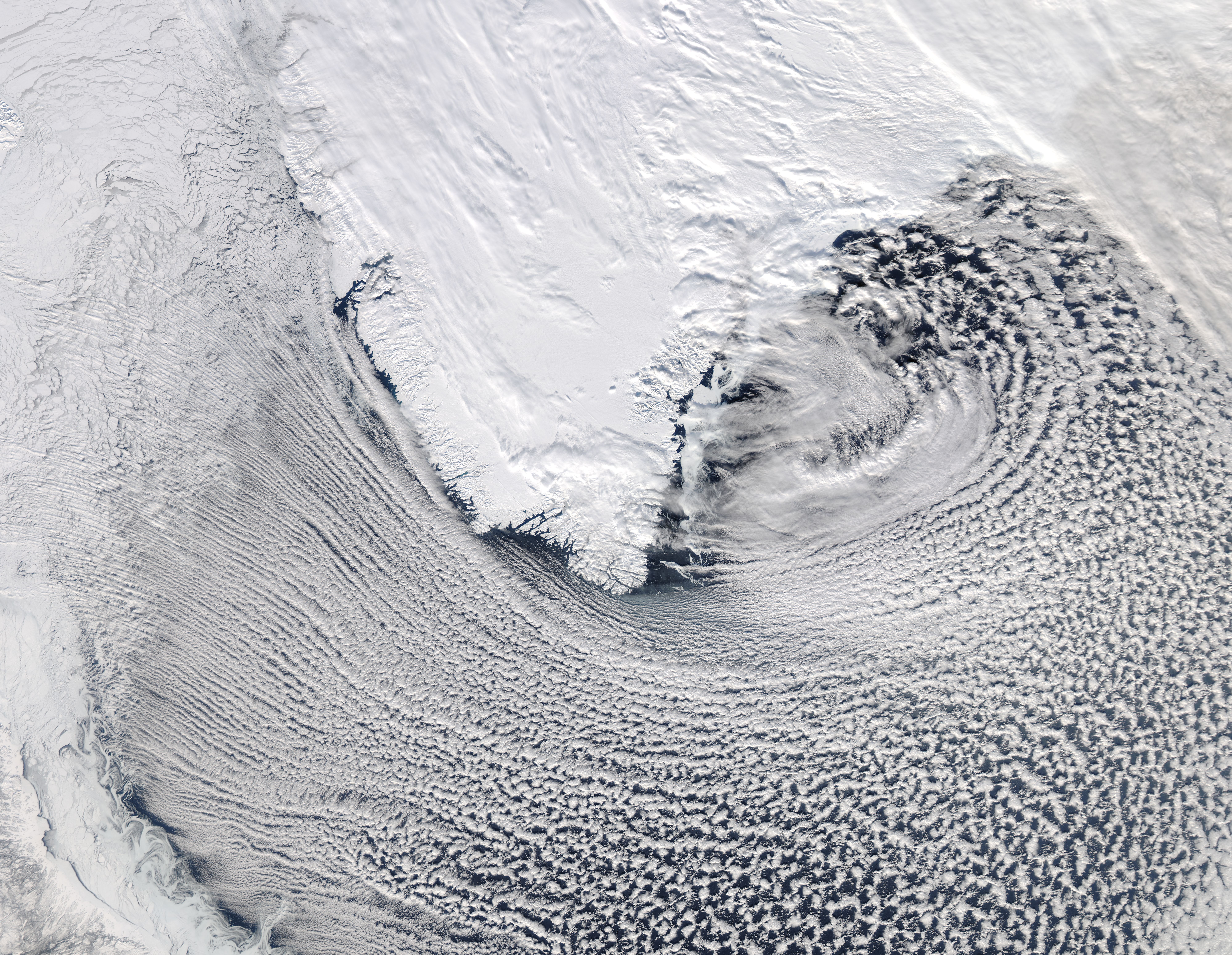
A mesmerizing pattern of clouds surrounding southern Greenland was spotted by a NASA satellite in orbit around Earth.
The agency's Aqua satellite snapped this stunning image of cloud streets around Greenland's southern tip on March 6.
Cloud streets are bands of cumulus clouds that form parallel to the low-level wind direction when conditions are right, scientists from NASA's Goddard Space Flight Center in Greenbelt, Md. said in a statement.
These clouds form by convection, which is the process in which lower density warm air rises as cold air sinks. As the sun shines and heats the moist air at ground level, it begins to rise. As this air rises, it begins to cool. When it reaches a certain temperature, the water in the air condenses onto tiny particles that are suspended in the atmosphere to form clouds.
Cloud streets form in the lowest part of the atmosphere, called the planetary boundary layer. These long rolls of air develop roughly parallel with the ground and can form over water or land.
This natural phenomenon creates fascinating views from below, but when these cloud patterns stretch across hundreds of kilometers, the spectacle is more dramatic as seen from above, NASA scientists said.
This true-color image was captured by the Moderate Resolution Imaging Spectroradiometer instrument aboard NASA's Earth-watching Aqua satellite.
Breaking space news, the latest updates on rocket launches, skywatching events and more!
Aqua flies roughly 438 miles (705 kilometers) above sea level, and is designed to collect a variety of observations and images of the planet from this orbital perch. The satellite's MODIS instrument scans the entire surface of the planet every one to two days, providing scientists with data on global processes on land, in the oceans and in the lower atmosphere.
Aqua was launched on May 4, 2002, and carries six onboard instruments that constantly monitor Earth's water cycle, including evaporation from oceans, clouds, water vapor in the atmosphere, precipitation, sea ice and snow cover.
This story was provided by OurAmazingPlanet, a sister site to SPACE.com. Follow OurAmazingPlanet for the latest in Earth science and exploration news on Twitter @OAPlanet and on Facebook.
For the science geek in everyone, Live Science breaks down the stories behind the most interesting news and photos on the Internet, while also digging up fascinating discoveries that hit on a broad range of fields, from dinosaurs and archaeology to wacky physics and astronomy to health and human behavior. If you want to learn something interesting every day, Live Science is the place for you.

