


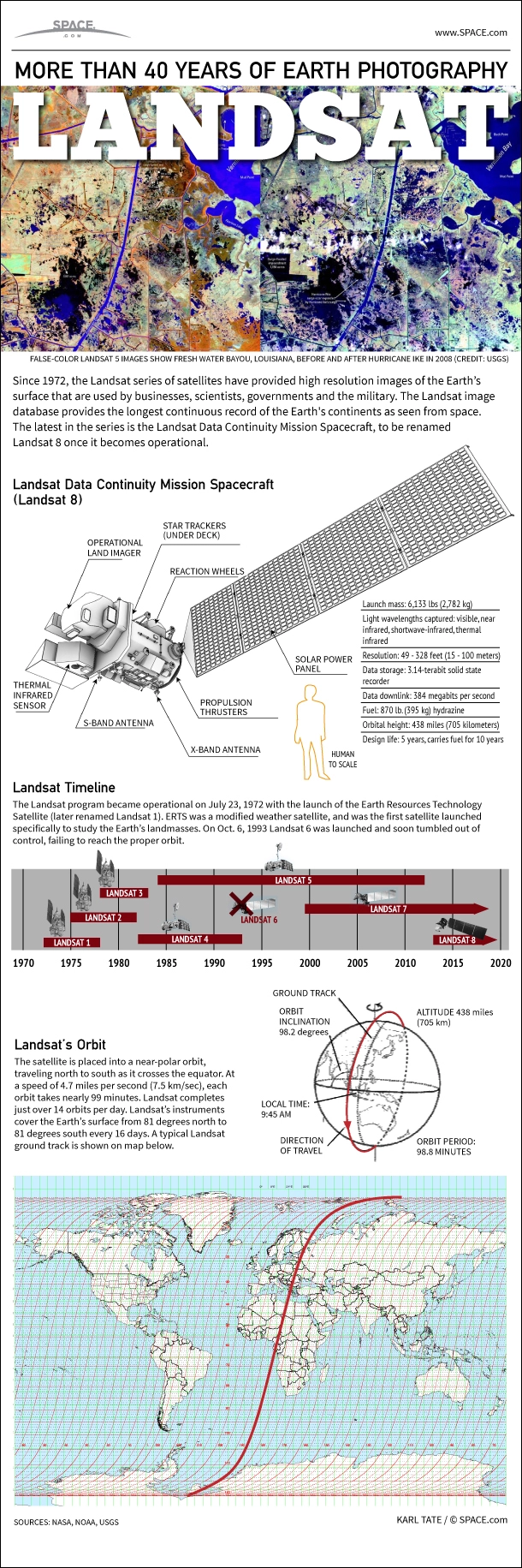
Since 1972, the Landsat series of satellites have provided high resolution images of the Earth’s surface that are used by businesses, scientists, governments and the military. The Landsat image database provides the longest continuous record of the Earth's continents as seen from space. The latest in the series is the Landsat Data Continuity Mission spacecraft, to be renamed Landsat 8 once it becomes operational.
At launch, the Landsat 8 satellite weighs 6,133 pounds (2,782 kilograms). Sensors on the spacecraft capture light in various wavelengths including visible, near infrared, shortwave-infrared and thermal infrared.
Images taken by Landsat 8 have a resolution of 49 to 328 feet (15 to 100 meters). The spacecraft's computer can store 3.14 terabits on a solid state recorder. Data beams down from the satellite at a rate of up to 384 megabits per second. [Photos: The Landsat 8 Earth-Observing Spacecraft]
Landsat 8 carries 870 pounds (395 kg) of hydrazine fuel, enough to last 10 years. The spacecraft orbits at an altitude of 438 miles (705 kilometers).
The Landsat program became operational on July 23, 1972 with the launch of the Earth Resources Technology Satellite (later renamed Landsat 1). ERTS was a modified weather satellite, and was the first satellite launched specifically to study the Earth’s landmasses. On Oct. 6, 1993, Landsat 6 was launched and soon tumbled out of control, failing to reach the proper orbit.
The Landsat spacecraft is placed into a near-polar orbit, traveling north to south as it crosses the equator. At a speed of 4.7 miles per second (7.5 km/sec), each orbit takes nearly 99 minutes. Landsat completes just over 14 orbits per day. Landsat’s instruments cover the Earth's surface from 81 degrees north to 81 degrees south every 16 days.
- Earth Pictures From Space: Landsat Satellite Legacy
- Earth Quiz: Do You Really Know Your Planet?
- Top 10 Game-Changing Earth Photos From Landsat Satellites
Follow SPACE.com on Twitter @Spacedotcom. We're also on Facebook & Google+.
