NASA space lasers track Earth's disappearing ice sheets and sea-level rise
"The new analysis reveals the ice sheets' response to changes in climate with unprecedented detail."
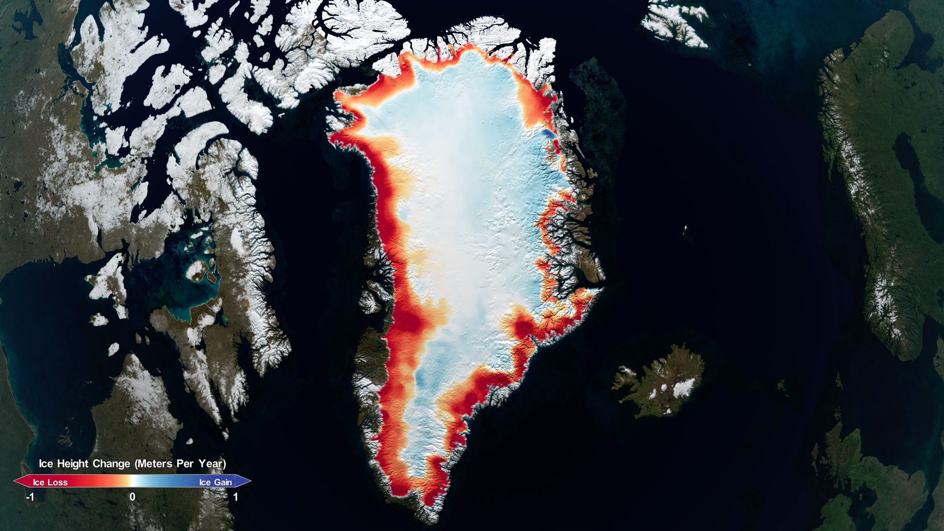
Using NASA space lasers, scientists have tracked how ice sheets in Greenland and the Antarctic have changed over the last 16 years, showing the drastic effects of climate change.
The research relied on observations from NASA's Ice, Cloud and Land Elevation Satellite (ICESat), which launched in 2003, and its successor ICESat-2, which launched in 2018 as one of the most advanced Earth-observing laser instruments. Using that data, scientists have shown that, while ice has increased a tiny amount in East Antarctica, West Antarctica has lost an enormous amount of ice.
This study revealed that Greenland's ice sheet lost an average of 200 gigatons of ice per year while Antarctica's lost an average of 118 gigatons of ice per year. For reference, one gigaton of ice can fill 400,000 Olympic-sized swimming pools, according to a NASA statement. The combined ice loss in Greenland and Antarctica has lifted sea levels by 0.55 inches (14 millimeters) between 2003 and 2019.
Related: The effects of global warming
"If you watch a glacier or ice sheet for a month, or a year, you're not going to learn much about what the climate is doing to it," Ben Smith, a glaciologist at the University of Washington and lead author of this new paper, said in the same statement. "We now have a 16-year span between ICESat and ICESat-2 and can be much more confident that the changes we're seeing in the ice have to do with the long-term changes in the climate."
To come to this conclusion, the researchers overlaid measurements gathered by ICESat between 2003 and 2009 with more recent ones that ICESat-2 took in 2019. They used data from tens of millions of different points where the two datasets met and, by comparing the two sets, they were able to see how much the elevation had changed.
The scientists in this study also developed a new model to calculate density across ice sheets, which allowed them to calculate total ice-sheet mass and therefore total mass loss.
Breaking space news, the latest updates on rocket launches, skywatching events and more!
ICESat-2, like its predecessor, is a laser altimeter. It sends 10,000 pulses of light per second down to Earth. These beams bounce right back to the satellite. The satellite is so precise that it can show how Earth's surface changes down to an inch.
This work shows exactly how climate change is affecting these ice sheets, which in turn affects sea levels. Although snowfall in certain parts of Antarctica has increased, causing the ice sheet to thicken, this gain is far outweighed by the extreme loss in ice caused by a warming ocean, according to the statement.
"The new analysis reveals the ice sheets' response to changes in climate with unprecedented detail, revealing clues as to why and how the ice sheets are reacting the way they are," Alex Gardner, a glaciologist at NASA's Jet Propulsion Laboratory in California and co-author on the paper, said in the statement.
These findings were published April 30 to the journal Science.
- The reality of climate change: 10 myths busted
- Earth quiz: Do you really know your planet?
- Jeff Bezos lays out Blue Origin's rocket reusability vision for space travel
Follow Chelsea Gohd on Twitter @chelsea_gohd. Follow us on Twitter @Spacedotcom and on Facebook.
OFFER: Save 45% on 'All About Space' 'How it Works' and 'All About History'!
For a limited time, you can take out a digital subscription to any of our best-selling science magazines for just $2.38 per month, or 45% off the standard price for the first three months.

Chelsea “Foxanne” Gohd joined Space.com in 2018 and is now a Senior Writer, writing about everything from climate change to planetary science and human spaceflight in both articles and on-camera in videos. With a degree in Public Health and biological sciences, Chelsea has written and worked for institutions including the American Museum of Natural History, Scientific American, Discover Magazine Blog, Astronomy Magazine and Live Science. When not writing, editing or filming something space-y, Chelsea "Foxanne" Gohd is writing music and performing as Foxanne, even launching a song to space in 2021 with Inspiration4. You can follow her on Twitter @chelsea_gohd and @foxannemusic.


