NASA Sees Massive Winter Storm Moving East

Breaking space news, the latest updates on rocket launches, skywatching events and more!
You are now subscribed
Your newsletter sign-up was successful
Want to add more newsletters?

Delivered daily
Daily Newsletter
Breaking space news, the latest updates on rocket launches, skywatching events and more!

Once a month
Watch This Space
Sign up to our monthly entertainment newsletter to keep up with all our coverage of the latest sci-fi and space movies, tv shows, games and books.

Once a week
Night Sky This Week
Discover this week's must-see night sky events, moon phases, and stunning astrophotos. Sign up for our skywatching newsletter and explore the universe with us!

Twice a month
Strange New Words
Space.com's Sci-Fi Reader's Club. Read a sci-fi short story every month and join a virtual community of fellow science fiction fans!
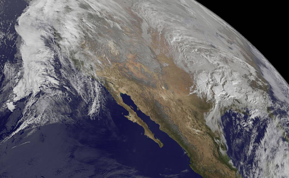
A massive winter storm that is expected to bring snow and ice to the eastern United States in the next 48 hours dwarfs the central part of the country in a new satellite image.
The National Oceanic and Atmospheric Administration's GOES-West satellite spotted this cloudy view of the large storm near the Gulf Coast today (Jan. 21) at 10 a.m. EST. (The satellite photo also spied a separate storm swirling over the Pacific Ocean.)
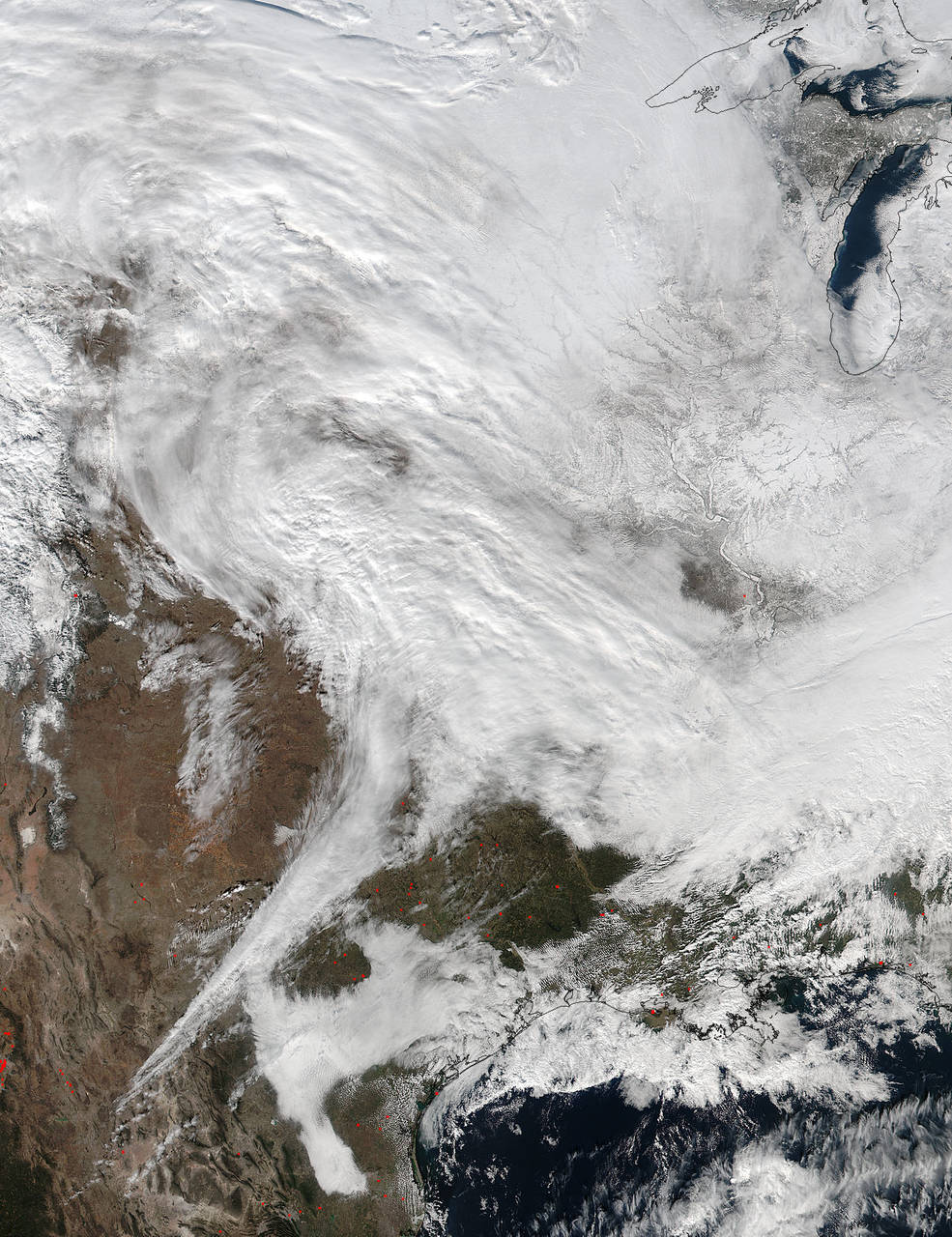
The NASA-NOAA Suomi NPP satellite captured another view of the looming winter storm yesterday (Jan. 20) at 2:30 p.m. EST, showing clouds and snow cover stretching from northern Texas into the Great Lakes states. The low-pressure system, which originated in the Eastern Pacific, is headed toward the mid-Atlantic states. The National Weather Service is warning of a potentially "crippling" snowstorm in those areas tomorrow and Saturday. [VIDEO: Watch the Developing Storm from Space]
Much of the East, from as far south as northern Georgia to as far north as New York City, is under weather alert, ranging from winter storm warnings in eastern Tennessee, Kentucky and western North Carolina to a blizzard watch in Washington, D.C, Baltimore and up the I-95 corridor through New Jersey.
"At this moment, this still looks like it's going to be northern Virginia and Maryland's most memorable snow," said David Robinson, the state climatologist of New Jersey. "A question remains just where exactly the heaviest snowfall totals will fall, just where the strongest winds will be and where the coastal flooding will be worst."
The storm will track across the Tennessee Valley tonight and Friday, ultimately hitting the mid-Atlantic states Saturday, with lessening snow expected by Sunday. Storms like the one bearing down on the eastern United States typically have a band of heavy snowfall about 100 miles (161 kilometers) wide, Robinson told Live Science. North of this band, precipitation peters out, leading to low overall totals. South of this band, temperatures are warm enough that snow turns to rain.
"This is a multifaceted nor'easter, as they all tend to be, laden with strong wind and impacts on the coast and heavy precipitation of one form or another," Robinson said.
Breaking space news, the latest updates on rocket launches, skywatching events and more!
El Niño's influence may also be at play, Robinson said. The storm "fits the pattern of volatility that we often see in weather, really across the country, during an El Niño winter," he said.
The winter of 2015-2016 has so far been marked by an active storm pattern in the western United States, with unseasonably warm temperatures and unusual midwinter thunderstorms in the South. In late December and early January, the Mississippi River flooded to levels not seen since 1993, thanks to heavy snows and rainfall in the western and central parts of the country. A rare December tornado outbreak from Indiana to Alabama killed 13 people between Dec. 23 and Dec. 25.
Meanwhile, warm temperatures made Christmas a balmy holiday for many on the East Coast. New York City experienced its warmest Christmas on record, with temperatures reaching 66 degrees Fahrenheit (19 degrees Celsius). On Christmas Eve, the mercury hit 72 degrees F (22 degrees C) at LaGuardia Airport in New York, breaking a 76-year record. The previous high temperature that day, according to NOAA's National Centers for Environmental Information, was 63 degrees F (17 degrees C).
Ice, wind and floods
If volatility is a feature of El Niño winters in the United States, so is an active East Coast storm track, Robinson said.
"We have seen coastal storms aplenty during El Niño winters," he said. Those storms don't always translate to snow, though, he added. Some mid-Atlantic El Niño years have been virtually snow-free, while others have seen large snowstorms.
Regardless of snow totals, the incoming storm is likely to be a major event, meteorologists say. Forecasts predict water levels 3 to 4 feet higher than normal along the New Jersey coast down into Delaware, Robinson said, and winds could gust more than 60 mph (96.5 km/h).
Washington, D.C., and the surrounding area is under a blizzard warning, with about 24 inches (60 centimeters) of snow expected for the capital city and 24 to 30 inches (60 to 76 cm) in the western suburbs, according to the National Weather Service. Gusty winds, ice and up to a foot (30 cm) of snow are expected in Kentucky. Detailed regional weather advisories and forecaster discussions can be found at http://www.weather.gov/.
Follow Stephanie Pappas on Twitter and Google+. Follow us @livescience, Facebook & Google+. Original article on Live Science.

Stephanie Pappas is a contributing writer for Space.com sister site Live Science, covering topics ranging from geoscience to archaeology to the human brain and behavior. She was previously a senior writer for Live Science but is now a freelancer based in Denver, Colorado, and regularly contributes to Scientific American and The Monitor, the monthly magazine of the American Psychological Association. Stephanie received a bachelor's degree in psychology from the University of South Carolina and a graduate certificate in science communication from the University of California, Santa Cruz.


