Military, Civilian Satellite Tools Help In Hurricane Response

BOULDER, Colorado -- The horrific tragedy spurred by Hurricane Katrina is being gauged by an array of both military and commercial satellite, as well as aerial sensors.
These tools, coupled with computer technology and geographical information system (GIS) software, are pieces of an unprecedented and still-unfolding ability to deal with natural, as well as human-made disasters.
Playing a key role in merging both classified and commercial satellite assets is the National Geospatial-Intelligence Agency, or NGA. It is working with the Federal Emergency Management Agency (FEMA) to appraise damage, as well as begin plotting out action plans.
This agency of the U.S. Department of Defense -- known earlier as the National Imagery and Mapping Agency (NIMA) -- provides timely, relevant, and accurate geospatial intelligence in support of U.S. national security and war-fighting objectives.
In this case, the battleline is the damage left in the wake of Hurricane Katrina.
Eyes in the Skies
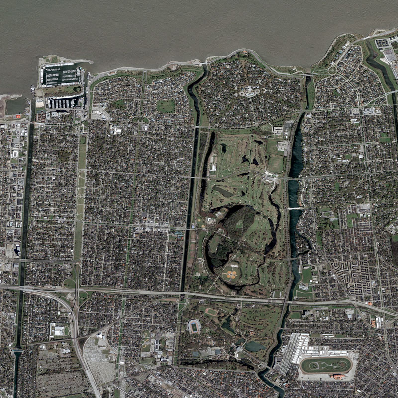
NGA is using spysat-snapped photos as well as commercial remote sensing spacecraft to piece together before-and-after data sets that capture the hurricane's harmful power.
Breaking space news, the latest updates on rocket launches, skywatching events and more!
"Observers on the ground provide a close-in view of a disaster. Aircraft can provide a broader view. But NGA using our satellites - U.S. government and commercial -- provide a different view," said Howard Cohen, an NGA spokesman.
"With these satellites NGA provides FEMA with geospatial information that can cover the affected states," Cohen told SPACE.com. "With information provided by these assets FEMA is better able to make assessments on the overall damage and decide where to focus resources," he said.
Not only are satellites being called into action. Dispatched from Beale Air Force Base in California on September 1, a U-2 Dragonlady aircraft conducted a surveillance flyover of hard-hit areas due to Hurricane Katrina.
During a six-hour mission, the piloted U-2 put to use an Optical Bar Camera (OBC), hardware ideal for photographing very large areas with high resolution. The OBC, or film-based imagery equipment utilized, can collect imagery over 90,000 square nautical miles.
Film taken during the high-altitude run by the U-2 is in support of FEMA to assist in disaster relief efforts, according to a U.S. Air Force press statement.
"This is our tsunami...here in the United States," said Joanne Gabrynowicz, Director of the National Remote Sensing and Space Law Center, situated at the University of Mississippi School of Law in University, Mississippi.
"We have to learn how to respond to these immediate, harsh, devastating natural events. We have to think hard and long about land use...about migrating people. We need to see it that way," Gabrynowicz told SPACE.com.
"There are so many dimensions of this. While there were some preparations taken...we weren't prepared for something of this magnitude." Gabrynowicz said she sees one particular bright spot given the scope of the tragic consequences of Hurricane Katrina.
International Charter
For one, there has been rapid use of satellite remote sensing tools. Specifically, Gabrynowicz spotlighted the International Charter on Space and Major Disasters.
The International Charter is scripted to create a unified system of space data acquisition and delivery to those affected by natural or human-made disasters. An authorized user of the charter agreement can now contact a single confidential point to request use of satellite and ground capabilities in post-disaster assessments.
Following a UNISPACE III conference held in Vienna, Austria back in July 1999 -- and kick-started by the European and French space agencies -- a "Charter On Cooperation To Achieve The Coordinated Use Of Space Facilities In The Event Of Natural Or Technological Disasters" has been established.
The Canadian Space Agency signed the Charter in 2000, followed by the U.S. National Oceanic and Atmospheric Administration in 2001. The Indian Space Research Organization also became a member of the Charter.
The Argentine Space Agency joined in July 2003, with the Japan Aerospace Exploration Agency becoming a member earlier this year.
Needed: pre-disaster activation
To help in handling the aftermath of Hurricane Katrina, the U.S. Geological Survey has requested aide via the Charter to help assess stricken areas of Louisiana, Mississippi, and Alabama.
The Charter has been activated numbers of times over the years, Gabrynowicz noted. "What has happened this time is that it was activated when Katrina went over Florida. This is the first time that the United States is the recipient of the benefit of this Charter," she added.
Gabrynowicz said one criticism of the Charter is that it requires the disaster to have already taken place. "You can't activate the Charter in advance of the disaster...which is understandable for earthquakes. But it might make sense to modify it in certain circumstances to allow pre-disaster activation," she said.
The Charter "does make a difference," Gabrynowicz suggested. Satellite-gleaned data is accessible more quickly, she said, and those hit by a disaster can have access to some systems that were previously not available.
Updated imagery
Commercial high-resolution remote sensing satellite operators - Digital Globe of Longmont, Colorado and Space Imaging of Thornton, Colorado - have been busy targeting the zones of demolition left by Hurricane Katrina.
DigitalGlobe is putting all available resources in collecting processing and disseminating satellite imagery of the gulf coast, said Chuck Herring as Director of Marketing Communications for the company.
"We are working with individuals, organizations, government agencies at all levels so that they can get updated imagery. Everyone in the region and around the world wants to get updated imagery to understand the magnitude of damage in the gulf coast area," Herring said.
Clearing the decks
One of the key satellites being utilized is Ikonos, a private Earth imaging spacecraft operated by Space Imaging.
The remote sensing satellite has already snapped dozens of images of the hurricane ravaged areas, said Gary Napier, a spokesman for Space Imaging. "We've completely cleared the decks," he said, with the firm putting Ikonos on a large and aggressive image-taking schedule since the hurricane landed.
NGA is buying Ikonos imagery and is also helping Space Imaging to prioritize what the satellite should photograph from high above Earth, based on the spacecraft's over-flight of hard-hit areas.
In addition to real-time imagery, Space Imaging is diving into its large archive of remote sensing images -- upwards of 1.7 million pictures obtained by Ikonos around the globe -- Napier pointed out, and culling out photos taken of areas prior to Hurricane Katrina's landfall.
Change detection maps
"NGA is one of our primary customers. We are talking with FEMA about providing services such as developing change detection maps and doing image analysis," Napier told SPACE.com.
By comparing pre- and post-hurricane pictures of a targeted area, change detection products can be created, Napier said. Those products are invaluable to emergency teams and responding agencies that are dealing with the crisis.
The capacity to satellite image and disseminate those photos electronically -- as well as transform pictures into value-added products using new mapping tools - can help better understand the level of disarray resulting from a ruinous event like Hurricane Katrina, as well as plot out correction actions.
"That capability wasn't available just five years ago," Napier said.

Leonard David is an award-winning space journalist who has been reporting on space activities for more than 50 years. Currently writing as Space.com's Space Insider Columnist among his other projects, Leonard has authored numerous books on space exploration, Mars missions and more, with his latest being "Moon Rush: The New Space Race" published in 2019 by National Geographic. He also wrote "Mars: Our Future on the Red Planet" released in 2016 by National Geographic. Leonard has served as a correspondent for SpaceNews, Scientific American and Aerospace America for the AIAA. He has received many awards, including the first Ordway Award for Sustained Excellence in Spaceflight History in 2015 at the AAS Wernher von Braun Memorial Symposium. You can find out Leonard's latest project at his website and on Twitter.
