


Inferno Down Below: Satellites Reveal Burning California Wildfires
Plumes of dense, gray smoke rise from deadly wildfires burning across multiple locations in California, in a striking animation of satellite images shared online Tuesday (Oct. 10) by the Cooperative Institute for Research in the Atmosphere (CIRA).
CIRA, a research institution at Colorado State University, operates in collaboration with the National Oceanic and Atmospheric Administration (NOAA) to track and analyze weather data collected by satellites.
The sequence, which lasts for just a few seconds, was created with preliminary data captured by a satellite with the Geostationary Operational Environmental Satellite (GOES) system, known as GOES-16. CIRA processed the data with a visualization tool called GeoColor, which displays satellite data of land and shallow water features in true color. In the animated sequence of wildfire images, GeoColor combined with the natural color of the fires, rendered in the red, blue and green (RGB) color model, accounting for the realistic detail of the wildfires' smoke and flames. [Wildfires Blaze in Northern California (Photos)]
Since Sunday (Oct. 8), fast-moving wildfires have blazed across eight counties in Northern California's wine country, sparked by hot, dry conditions and fueled by gusting winds, which are also impeding the firefighters' progress. The fires claimed the lives of 23 people, destroyed approximately 3,500 buildings and scorched more than 170,000 acres (about 69,000 hectares), leading to the evacuation of over 20,000 people, ABC News reported today (Oct. 12).
And the destructive fires in the Sonoma and Napa valleys are not slowing down, NASA representatives said yesterday (Oct. 11) in a statement.
In neighborhoods left charred and smoking in the wildfires' wake, "acres of standing fireplaces" are the only surviving remnants of the homes that once stood there, and thousands more homes are threatened by the encroaching flames, according to NASA.
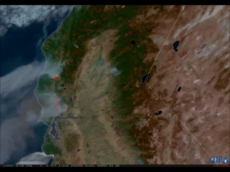
In a natural-color image captured by NASA's Terra satellite Tuesday (Oct. 10) using the Moderate Resolution Imaging Spectroradiometer (MODIS), so-called "hotspots" — areas where fires are actively burning — are highlighted with red outlines.

"Each hot spot is an area where the thermal detectors on the MODIS instrument recognized temperatures higher than background. When accompanied by plumes of smoke, as in this image, such hot spots are diagnostic for fire," NASA representatives explained in the statement.
Currently, 17 fires are active in northern California, according to a map generated by the California Department of Forestry and Fire Protection (CAL FIRE). Though wildfires are common in California during the month of October, the size and intensity of this year's fires are unusual, according to NASA.
Original article on Live Science.
