See Tropical Storm Gordon from the International Space Station (Video)
New footage from the International Space Station captured Tropical Storm Gordon as it grew stronger over the northern Gulf of Mexico.
The storm reached tropical storm strength on Monday (Sept. 3) as it passed over the Florida Keys. The video, taken yesterday (Sept. 4), tracked Gordon's progress as it surged over the northern Gulf of Mexico. From an altitude of 255 miles, cameras outside the space station watched as the storm moved northwest at 15 mph (24 km/h).
By last night, tropical storm force winds were blowing at a maximum sustained speed of 70 mph (113 km/h), suggesting that the storm had the potential to grow to a Category 1 hurricane before making landfall. This would have made Gordon the first hurricane to strike the continental United States this year. However, this morning (Sept. 5) it has weakened to a tropical depression, according to a public advisory from the National Oceanic and Atmospheric Administration's National Hurricane Center (NHC).

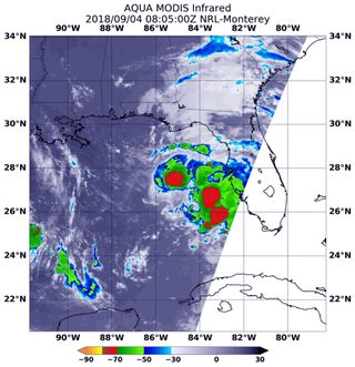
NASA's Aqua satellite also tracked the storm as it progressed inland yesterday. Infrared satellite data from Aqua's Moderate Resolution Imaging Spectroradiometer (MODIS) instrument identified the strongest areas of the storm where cloud-top temperatures were indicative of strong winds and heavy rain, according to a statement from NASA.
In several of the storm's strongest areas, MODIS recorded temperatures near minus 70 degrees Fahrenheit (minus 57 degrees Celsius) for some of the coldest cloud tops. Temperatures this low can generate heavy rainfall, according to the statement.
A hurricane warning was issued for the Alabama and Mississippi coasts, and parts of Louisiana and Florida are under a tropical storm warning. Also, a storm surge watch was issued for areas near the coasts of Mississippi, Alabama and the Florida Panhandle, where the storm could produce 4 to 8 inches (10 to 20 centimeters) of rain. Some areas may even receive 12 inches (30 cm) of rain through Thursday, causing flash flooding, according to the NHC.
Follow Samantha Mathewson @Sam_Ashley13. Follow us @Spacedotcom, Facebook and Google+. Original article on Space.com.
Get the Space.com Newsletter
Breaking space news, the latest updates on rocket launches, skywatching events and more!
Join our Space Forums to keep talking space on the latest missions, night sky and more! And if you have a news tip, correction or comment, let us know at: community@space.com.

Samantha Mathewson joined Space.com as an intern in the summer of 2016. She received a B.A. in Journalism and Environmental Science at the University of New Haven, in Connecticut. Previously, her work has been published in Nature World News. When not writing or reading about science, Samantha enjoys traveling to new places and taking photos! You can follow her on Twitter @Sam_Ashley13.
