1 of 30
Best View of Goulburn Scour
Credit: NASA/JPL-Caltech/MSSS
This image from NASA's Curiosity Rover shows a high-resolution view of an area that is known as Goulburn Scour, a set of rocks blasted by the engines of Curiosity's descent stage on Mars. Curosity's Mastcam obtained these images on Aug. 19, 2012, or the 13th sol, or Martian day, of Curiosity's surface operations. [Full Story]
2 of 30
Link to a Watery Past
Credit: NASA/JPL-Caltech/MSSS
In this image from NASA's Curiosity rover, a rock outcrop called Link pops out from a Martian surface that is elsewhere blanketed by reddish-brown dust. The Link outcrop was imaged with the 100-millimeter Mast Camera on Sept. 2, 2012, which was the 27th sol, or Martian day of operations. [Full Story]
3 of 30
Rock Outcrops on Mars and Earth
Credit: NASA/JPL-Caltech/MSSS and PSI
This set of images compares the Link outcrop of rocks on Mars (left) with similar rocks seen on Earth (right). The image of Link, obtained by NASA's Curiosity rover, shows rounded gravel fragments, or clasts, up to a couple inches (few centimeters), within the rock outcrop. The Link outcrop was imaged with the 100-millimeter Mast Camera on Sept. 2, 2012, which was the 27th sol, or Martian day of operations. [Full Story]
4 of 30
Dry Streambed on Alluvial Fan in Northern Chile
Credit: UC Berkeley
This image shows a dry streambed on an alluvial fan in the Atacama Desert, Chile, revealing the typical patchy, heterogeneous mixture of grain sizes deposited together. On Mars, Curiosity has seen two rock outcrops close to its Bradbury Landing site that also record a mixture of sand and pebbles transported by water that were most likely deposited along an ancient streambed. Image released September 27, 2012.
5 of 30
Martian Moon Phobos Seen by Curiosity Rover, Closeup
Credit: NASA/JPL
This close up from a photo by NASA's Mars rover Curiosity shows the Martian moon Phobos as a faint crescent in the Martian evening sky. The black blemish is the result of a bad pixel in the image data. Image released Sept. 26, 2012. [Full Story]
6 of 30
Martian Moon Phobos Seen by Curiosity Rover
Credit: NASA/JPL
NASA's Mars rover Curiosity snapped this photo of the largest Martian moon Phobos during a Mars sky observing session. Phobos is Mars' largest moon, but only 14 miles across. Image released Sept. 26, 2012. [Full Story]
7 of 30
Curiosity's Robotic Arm Touching Rock 'Jake Matijevic'
Credit: NASA/JPL-Caltech
NASA's Curiosity rover performs "contact science" operations on a rock called "Jake Matijevic" in this photo, which was snapped Sept. 22, 2012. [Full Story]
8 of 30
Mars Rover Touches 1st Rock (Closeup)
Credit: NASA/JPL-Caltech/MSSS
This image combines photographs taken by the Mars Hand Lens Imager (MAHLI) at three different distances from the first Martian rock that NASA's Curiosity rover touched with its arm. The three exposures were taken during the 47th Martian day, or sol, of Curiosity's work on Mars (Sept. 23, 2012). The team has named the target rock "Jake Matijevic." The scale bar is 4 centimeters (1.6 inches). [Full Story]
9 of 30
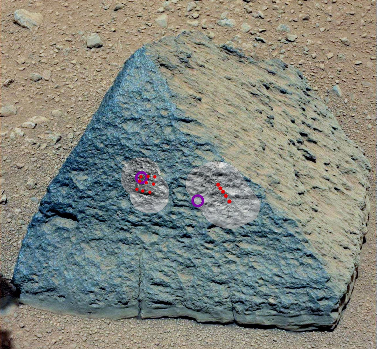
Curiosity Rover's Rock Named Jake Matijevic
Credit: NASA/JPL-Caltech
The drive by NASA's Mars rover Curiosity during the mission's 43rd Martian day, or sol, (Sept. 19, 2012) ended with this rock about 8 feet (2.5 meters) in front of the rover. The rock is about 10 inches (25 centimeters) tall and 16 inches (40 centimeters) wide.The rock has been named "Jake Matijevic" after Jacob Matijevic (1947-2012), who was the surface operations systems chief engineer for Curiosity's mission.
10 of 30
Mars Rover Curiosity Sees Phobos
Credit: NASA/JPL-Caltech/MSSS
As part of a multi-mission campaign, NASA's Curiosity rover is observing Martian moon transits, the first of which involved the moon Phobos grazing the sun's disk. The event was observed on Martian day, or sol, 37 (September 13, 2012) using Curiosity's Mast Camera, or Mastcam, equipped with special filters for directly observing the sun
11 of 30
Curiosity Rover's Mars Drive Map: 9/19/12
Credit: NASA/JPL-Caltech/Univ. of Arizona
This map shows the route driven by NASA's Mars rover Curiosity through the 43rd Martian day, or sol, of the rover's mission on Mars (Sept. 19, 2012). By Sol 43, Curiosity had driven at total of about 950 feet (290 meters).
12 of 30
Curiosity Mars Rover's Close Views Glenelg Features
Credit: NASA/JPL-Caltech/MSSS
This mosaic from the Mast Camera on NASA's Curiosity rover shows a close-up view looking toward the "Glenelg" area, where three different terrain types come together. Image released Sept. 19, 2012
13 of 30
Curiosity Mars Rover Views Glenelg Features
Credit: NASA/JPL-Caltech/MSSS
This seven-image mosaic from the Mast Camera on NASA's Curiosity rover shows the view looking toward the "Glenelg" area, where three different terrain types come together. Image released on Sept. 19, 2012.
14 of 30
Belly Check for Curiosity
Credit: NASA/JPL-Caltech/Malin Space Science Systems
This view of the lower front and underbelly areas of NASA's Mars rover Curiosity was taken by the rover's Mars Hand Lens Imager (MAHLI) during the 34th Martian day, or sol, of Curiosity's work on Mars. This image was taken Sept. 9, 2012.
15 of 30
Rover Takes Self Portrait
Credit: NASA/JPL-Caltech/Malin Space Science Systems
On Sol 32 (Sept. 7, 2012) the Curiosity rover used a camera located on its arm to obtain this self portrait. The image of the top of Curiosity's Remote Sensing Mast, showing the Mastcam and Chemcam cameras, was acquired by the Mars Hand Lens Imager (MAHLI).
16 of 30
Mars Hand Lens Imager (MAHLI)
Credit: NASA/JPL-Caltech/MSSS
This image shows the Mars Hand Lens Imager (MAHLI) on NASA's Curiosity rover, with the Martian landscape in the background. The image was taken by Curiosity's Mast Camera on the 32nd Martian day, or sol, of operations on the surface (Sept. 7, 2012, PDT or Sept. 8, 2012, UTC).
17 of 30
Portrait of APXS on Mars
Credit: NASA/JPL-Caltech/MSSS/NMMNHS
This image shows the Alpha Particle X-Ray Spectrometer (APXS) on NASA's Curiosity rover, with the Martian landscape in the background. The image was taken by Curiosity's Mast Camera on the 32nd Martian day, or sol, of operations on the surface (Sept. 7, 2012, PDT or Sept. 8, 2012, UTC). APXS can be seen in the middle of the picture.
18 of 30
Lincoln with Mars Sand Grains
Credit: NASA/JPL-Caltech/MSSS
This close-up image shows Martian sand grains that settled on the penny that serves as a calibration target on NASA's Curiosity rover. Image released September 12, 2012.
19 of 30
Mars Rover Curiosity: Wheel-Gazing
Credit: NASA/JPL-Caltech/Malin Space Science Systems
This view of the three left wheels of NASA's Mars rover Curiosity combines two images that were taken by the rover's Mars Hand Lens Imager (MAHLI) during the 34th Martian day, or sol, of Curiosity's work on Mars (Sept. 9, 2012). In the distance is the lower slope of Mount Sharp.
20 of 30
Calibration Target for Curiosity's Arm Camera
Credit: NASA/JPL-Caltech/Malin Space Science Systems
This view of the calibration target for the Mars Hand Lens Imager (MAHLI) aboard NASA's Mars rover Curiosity combines two images taken by that camera during the 34th Martian day, or sol, of Curiosity's work on Mars. This image was taken Sept. 9, 2012.
21 of 30
Mars Rover Curiosity's Lucky Penny
Credit: NASA/JPL-Caltech/Malin Space Science Systems
The penny in this image is part of a camera calibration target on NASA's Mars rover Curiosity. The rover's arm-mounted The Mars Hand Lens Imager took this calibration image on Sept. 9, 2012.
22 of 30
First Image From Curiosity's Arm Camera With Dust Cover Open
Credit: NASA/JPL-Caltech/Malin Space Science Systems
The reclosable dust cover on Curiosity's Mars Hand Lens Imager (MAHLI) was opened for the first time during the 33rd Martian day, or sol, of the rover's mission on Mars. This image was taken Sept. 8, 2012.
23 of 30
Martian Ground Seen by Arm Camera With and Without Dust Cover
Credit: NASA/JPL-Caltech/Malin Space Science Systems
As the last step in a series of inspections of the Mars Hand Lens Imager (MAHLI) aboard NASA's Mars rover Curiosity, this camera's reclosable dust cover was opened for the first time during the 33rd Martian day, or sol, of the rover's mission on Mars. This image was taken Sept. 8, 2012.
24 of 30
Dissecting the Scene of Sky Crane Crash
Credit: NASA/JPL-Caltech/Univ. of Arizona
After a rocket-powered descent stage, also known as the sky crane, delivered NASA's Curiosity rover to Mars on Aug. 5 PDT (Aug. 6 EDT), 2012, it flew away and fell to the surface. Possible multiple impacts from that collision are revealed in blue in this enhanced-color view taken by the High-Resolution Imaging Science Experiment (HiRISE) camera on NASA's Mars Reconnaissance Orbiter.
25 of 30
Panorama of Curiosity's Belly Check
Credit: NASA/JPL-Caltech/Malin Space Science Systems
This view of the lower front and underbelly areas of NASA's Mars rover Curiosity combines nine images taken by the rover's Mars Hand Lens Imager (MAHLI) during the 34th Martian day, or sol, of Curiosity's work on Mars (Sept. 9, 2012).
26 of 30
Sealed Organic Check Material on Curiosity
Credit: NASA/JPL-Caltech/Malin Space Science Systems
NASA's Mars rover Curiosity carries five cylindrical blocks of organic check material for use in a control experiment if the rover's Sample Analysis at Mars (SAM) laboratory detects any organic compounds in samples of Martian soil or powdered rock. This image was taken Sept. 9, 2012.
27 of 30
A Piece of New Mexico on Mars
Credit: NASA/JPL-Caltech/Malin Space Science Systems
A sample of basaltic rock from a lava flow in New Mexico serves as a calibration target carried on the front of NASA's Mars rover Curiosity for the rover's Canadian-made Alpha Particle X-Ray Spectrometer (APXS) instrument. This image was taken Sept. 9, 2012.
28 of 30
'Bathurst Inlet' Rock on Curiosity's Sol 54, Close-Up View
Credit: NASA/JPL-Caltech/Malin Space Science Systems
This is the highest-resolution view that the Mars Hand Lens Imager (MAHLI) on NASA's Mars rover Curiosity acquired of the top of a rock called "Bathurst Inlet." This is a merged-focus view combining information from a set of eight images taken by MAHLI at different focus settings during Curiosity's 54th Martian day, or sol (Sept. 30, 2012).
29 of 30
Martian Streambed Evidence Rock in 3-D
Credit: NASA/JPL-Caltech/MSSS
This stereo image from the Mast Camera (Mastcam) on NASA's Mars rover Curiosity shows a rock outcrop called "Hottah," cited as evidence for vigorous flow of water in a long-ago Martian stream. The scene covers an area roughly 1 yard or meter across at the near edge. This imahe was taken on Sept. 15, 2012.
30 of 30
'Bathurst Inlet' Rock on Curiosity's Sol 54, Context View
Credit: NASA/JPL-Caltech/Malin Space Science Systems
NASA's Mars rover Curiosity held its Mars Hand Lens Imager (MAHLI) camera about 10.5 inches (27 centimeters) away from the top of a rock called "Bathurst Inlet" for a set of eight images combined into this merged-focus view of the rock. This image was taken Sept. 30, 2012.


