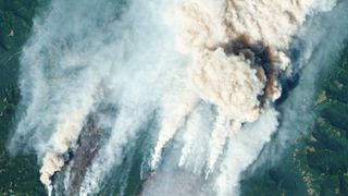
Satellite images show ravages of Western wildfires

Satellite views show massive clouds of wildfire smoke shrouding vast areas of the Oregon and Washington states as vicious blazes destroy hundreds of square miles of forest.
The Cedar Creek wildfire in the Willamette National Forest, lit by lightning in early August, according to NPR, is currently the largest of the nearly two dozen wildfires burning in the region.
Satellites watched as the Cedar Creek fire grew over the past weekend to 135 square miles (90 square kilometers). In an image captured by NASA's Terra satellite on Saturday (Sept. 10), smoke from the Cedar Creek Fire can be seen spreading along the Pacific coast and over the ocean. High levels of fire-related air pollution have been reported in the state's capital, Portland, reducing air quality to "very unhealthy" levels, according to a NASA statement.
Related: Satellites watch Europe dry up in devastating drought that may be the worst in 500 years


A smaller fire in the state of Washington, called the Bolt Creek Fire, is also generating thick plumes of smoke that are clearly visible from space. The fire, which ignited over the weekend in the western foothills of the Cascade Mountains, is polluting air in Seattle and its surroundings.
The Bolt Creek Fire spread across 12 square miles (32 square km) of land within a day, fanned by powerful winds of a low-pressure weather system approaching above the Pacific Ocean, NASA said in the statement.
The northwest is not the only region in the U.S. suffering from devastating wildfires. In what has been a summer of weather extremes all over the world — a sign of continuing climate change — the U.S. has experienced another above-average wildfire season, although not as devastating as the seasons of 2020 and 2021.
Get the Space.com Newsletter
Breaking space news, the latest updates on rocket launches, skywatching events and more!
In particular, California, plagued by an ongoing drought and severe heat waves, has witnessed a string of vicious blazes this year that have combined to ravage nearly 520 square miles (1,370 square km) of land. The Mosquito Fire in the Sierra Nevada foothills is currently the largest of the Californian wildfires, having destroyed over 47 square miles (120 square km) of forest since igniting last week.
Follow Tereza Pultarova on Twitter @TerezaPultarova. Follow us on Twitter @Spacedotcom and on Facebook.
Join our Space Forums to keep talking space on the latest missions, night sky and more! And if you have a news tip, correction or comment, let us know at: community@space.com.

Tereza is a London-based science and technology journalist, aspiring fiction writer and amateur gymnast. Originally from Prague, the Czech Republic, she spent the first seven years of her career working as a reporter, script-writer and presenter for various TV programmes of the Czech Public Service Television. She later took a career break to pursue further education and added a Master's in Science from the International Space University, France, to her Bachelor's in Journalism and Master's in Cultural Anthropology from Prague's Charles University. She worked as a reporter at the Engineering and Technology magazine, freelanced for a range of publications including Live Science, Space.com, Professional Engineering, Via Satellite and Space News and served as a maternity cover science editor at the European Space Agency.