Two enormous cracks in Earth's crust opened near the Turkish-Syrian border after two powerful earthquakes shook the region on Monday (Feb. 6), killing over 20,000 people.
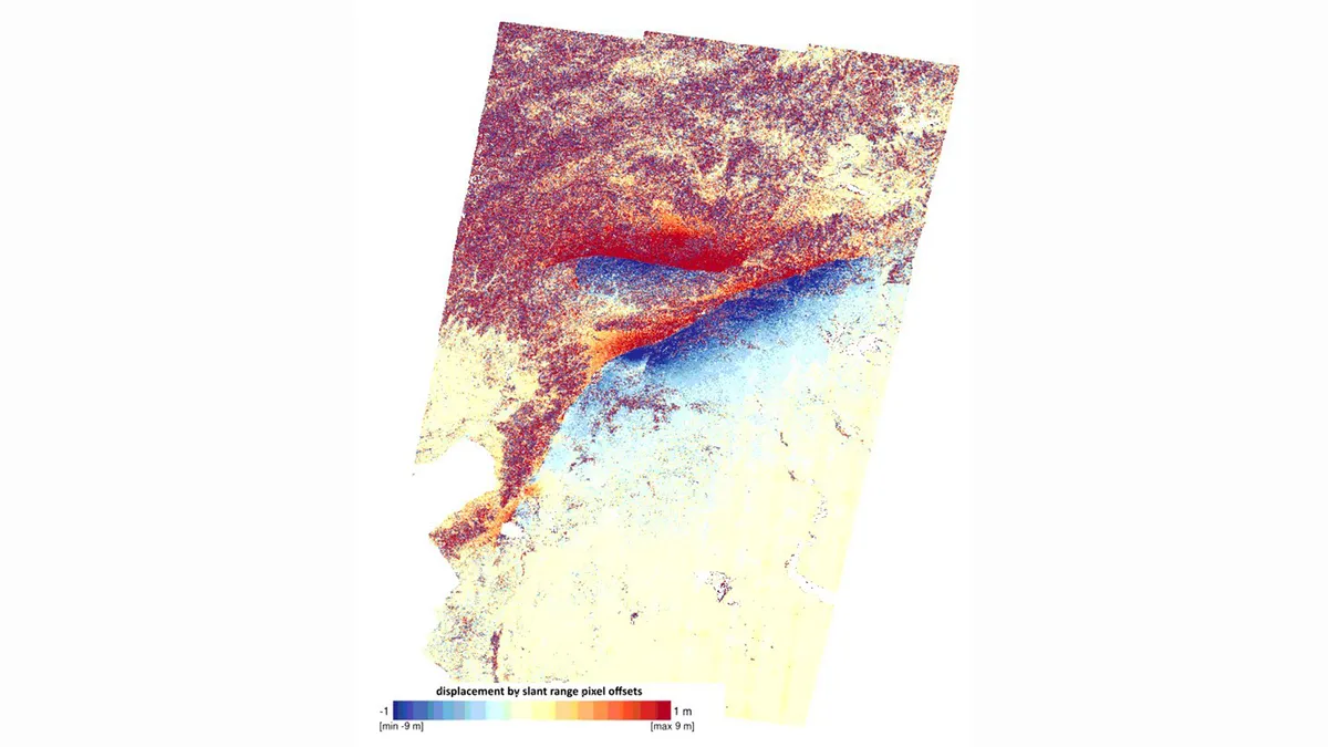
Researchers from the U.K. Centre for the Observation & Modelling of Earthquakes, Volcanoes & Tectonics (COMET) found the ruptures by comparing images of the area near the Mediterranean Sea coast taken by the European Earth-observing satellite Sentinel-1 before and after the devastating earthquakes.
The longer of the two ruptures stretches 190 miles (300 kilometers) in the northeastern direction from the northeastern tip of the Mediterranean Sea. The crack was created by the first of the two major tremors that hit the region on Monday, the more powerful 7.8-magnitude earthquake that struck at 4:17 a.m. local time (8:17 p.m. EST on Feb. 5). The second crack, 80 miles long (125 km), opened during the second, somewhat milder 7.5-magnitude temblor about nine hours later, COMET said in a tweet on Friday (Feb. 10).
Related: Turkey earthquake devastation spotted by satellites (photos)
Such ruptures appear commonly after powerful earthquakes, professor Tim Wright, who leads the COMET team, told Space.com in an email. These two fissures, however, are unusually long, a testament to the enormous amount of energy the earthquakes unleashed.
"The bigger the earthquake, the bigger the fault and the more it slips," Wright wrote. "This earthquake fault is one of the longest on record on the continents. Also very unusual to have two such large earthquakes happening within a few hours of each other."
The movement of the tectonic plates that caused the earthquakes was such that the cracks are clearly visible on the surface, running through towns and in some cases directly through buildings.
"We estimate presumably horizontal displacements of rarely up to 5 meters [16 feet]," COMET researcher Milan Lazecky told Space.com in an email. "Indeed, such large displacements of the terrain cannot be missed by people living in those regions."
Local scientists shared photographs of the surface cracks on Twitter, confirming what satellites observed from space.
Surface rupture at Hassa Town. #earthquake #deprem pic.twitter.com/klsw2zesYjFebruary 8, 2023
This area, north of Cyprus, is prone to powerful earthquakes, as three tectonic plates — the Anatolian, Arabian and African plates — meet here, creating pressure as they bump into each other. The Monday earthquakes, however, stood out with their ferocity and devastating effects, according to experts.
More than 20,000 people have been reported dead, and many victims are likely still buried underneath rubble as rescue operations proceed slowly, especially on the Syrian side, which has been ravaged by armed conflicts for years.
Since the earthquakes struck, satellites operated by governmental agencies as well as private companies have been assessing the damage. According to NASA, the earthquakes erupted along a fault line 11 miles (18 km) below the surface. This shallow depth, NASA said in the statement, meant tremors propagated with vicious force, spreading hundreds of miles away from the epicenter.
"These were very large and powerful earthquakes that ruptured all the way up to the surface over a long series of fault segments," Eric Fielding, a geophysicist at NASA’s Jet Propulsion Laboratory, said in the statement. "This generated extremely strong shaking over a very large area that hit many cities and towns full of people. The rupture length and magnitude of the magnitude-7.8 earthquake was similar to the 1906 earthquake that destroyed San Francisco."
Across the Turkish cities of Türkoğlu, Kahramanmaraş and Nurdaği, thousands of buildings have collapsed, burying their occupants and rendering thousands of people homeless.
Follow Tereza Pultarova on Twitter @TerezaPultarova. Follow us on Twitter @Spacedotcom and on Facebook.
Join our Space Forums to keep talking space on the latest missions, night sky and more! And if you have a news tip, correction or comment, let us know at: community@space.com.