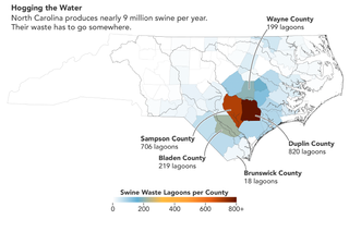
North Carolina is in hog heaven. Well, in a manner of speaking: It's one of the largest producers of swine in the U.S., with pigs nearly outnumbering the state's human population.
All of this pork production results in millions of tons of pig manure that needs to be collected, stored and treated in massive outdoor waste lagoons.
These vast brownish-pink ponds have multiplied in the past four decades as demand grows and North Carolina swine farmers have switched from raising pigs on large tracts of open land to concentrated animal feeding operations (CAFOs). Waste lagoons are necessary as receptacles of the waste products, where microbes break down organic material so some of it can be used to spray on crops as nutrient-rich fertilizer.
Related: The top 10 views of Earth from space
However, swine lagoons have some downsides, as you may have guessed. For example, excess nutrients from the waste in the form of nitrogen and phosphorus accumulate in lagoons and upend the natural equilibrium of local soils, groundwater and surface water.
To target the long-term effects to the environment and get a better view of where these pig poop lagoons are located, scientists are turning to the skies for help, analyzing detailed satellite imagery.
For example, Lise Montefiore and her team at North Carolina State University recently inspected decades of photos snapped by Landsat 5, a satellite operated by the U.S. Geological Survey and NASA that viewed Earth from 1984 to 2013.
Get the Space.com Newsletter
Breaking space news, the latest updates on rocket launches, skywatching events and more!
The researchers studied Landsat 5 images to observe the expansion of CAFO pig poop ponds to determine exactly where they're clustered and how long they've been in operation, publishing the results in February 2022 in the journal Nature Scientific Reports.

"Such information is useful for understanding how animal agriculture may pressure natural systems and impact adjacent communities," Montefiore said in a statement.
Spotting the telltale pink or brown geometric shapes of the waste lagoons is a lot like a dirty game of "Where's Waldo," and so far Montefiore and her colleagues have used Google Earth Pro's database to identify 3,405 waste lagoons spread along North Carolina's coastal plain.
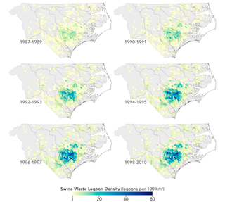
The satellite data reveal certain trends in lagoon construction dating back to the industrialization of pig farms in the state during the 1980s, past the moratorium on further construction of swine lots in 1997 and onward to more modern times, the researchers explained.
By focusing on 959 Landsat 5 images, the team was able to estimate when each lagoon was formed. Its age was marked as the point when the satellite recorded the land surface as changing from dry to wet.
This work revealed swift changes in the density of lagoons at local, sub-watershed scales. For example, the number of waste ponds increased from 197 to 436 between the years 1986 and 1997.
"The most interesting results speak to how dramatically the swine CAFO density and footprint increased in North Carolina over a relatively short time period," Montefiore said in the statement. "Such information is critical to understanding and assessing the long-term responses to management and water quality policies."
In the future, scientists believe that such data could help them build smarter water-quality models that assess the long-term effects of applying manure to crops, and to obtain more accurate readings on how long it takes for the land to recover from a poop lagoon's toxic nutrient buildup.
Follow us on Twitter @Spacedotcom or on Facebook.
Join our Space Forums to keep talking space on the latest missions, night sky and more! And if you have a news tip, correction or comment, let us know at: community@space.com.

Jeff Spry is an award-winning screenwriter and veteran freelance journalist covering TV, movies, video games, books, and comics. His work has appeared at SYFY Wire, Inverse, Collider, Bleeding Cool and elsewhere. Jeff lives in beautiful Bend, Oregon amid the ponderosa pines, classic muscle cars, a crypt of collector horror comics, and two loyal English Setters.
