Hurricane Ida expected to slam into Louisiana as 'extremely dangerous major hurricane'
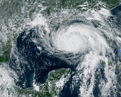
Hurricane Ida is barreling across the Gulf of Mexico with maximum sustained winds of nearly 100 mph (155 km/h). Its eye is trained on Louisiana, where the swirling storm is expected to make landfall as a Category 4 hurricane on Sunday, Accuweather forecasters said Saturday afternoon (Aug. 28).
The storm would be the first Atlantic hurricane of the 2021 season to make landfall on U.S. soil, Accuweather reported.
As of 1 p.m. CDT (1 p.m. EDT), Ida was about 290 miles (470 kilometers) south-southeast of the mouth of the Mississippi River and 380 miles (610 km) southeast of Houma, Louisiana. The massive storm is moving in the northwest direction at about 16 mph (26 km/h). As it treks over the warm Gulf of Mexico, the Category 2 hurricane is expected to pick up even more energy before slamming into the Louisiana coast.
Related: The 20 costliest, most destructive hurricanes to hit the US
"Preparations to protect life and property should be rushed to completion today in the warning area along the northern Gulf Coast," the National Hurricane Center said in a statement.
The NHC put out a hurricane warning for areas from Intracoastal City, Louisiana, to the Mouth of the Pearl River, also in Louisiana, as well as around Lake Pontchartrain, Lake Maurepas and Metropolitan New Orleans.
Though New Orleans Mayor Latoya Cantrell had called for mandatory evacuations around the levee system there, the state governor, John Bel Edwards, along with the National Weather Service, said there was no time to organize such an evacuation, Accuweather reported. Instead, Cantrell is now advising residents to voluntarily evacuate or "hunker down," according to Accuweather.
The eye of Ida is forecast to move across the southeastern and central Gulf of Mexico through Saturday night, before making landfall along the Louisiana coast in the hurricane warning area on Sunday as "an extremely dangerous major hurricane," the NHC said. Once on land, Ida should weaken while moving over inland portions of Louisiana and Mississippi later on Monday (Aug. 30).
Though high winds and heavy rainfall can wreak havoc on storm-hit areas, storm surge is often the most dangerous part of a hurricane, forecasters have said. If the peak storm surge coincides with high tide, the water in some places could reach dramatic heights. If that does occur, expect a surge of 10 to 15 feet (3 to 4.6 meters) from Morgan City, Louisiana, to the mouth of the Mississippi River. From there to Ocean Springs, Mississippi, peak surge could reach 7 to 11 feet (2.1 to 3.4 m), the NHC said.
Hurricane Ida is making landfall on the exact date that Hurricane Katrina hit the area 16 years ago. Katrina had intensified to a Category 5 storm the day prior to landfall as it swirled in the Gulf of Mexico. The storm weakened to a Category 3 hurricane by the time it made landfall on the morning of Aug. 29, 2005, along the Louisiana-Mississippi border with maximum sustained winds of 120 mph (193 km/h), Live Science reported. Katrina is considered one of the deadliest hurricanes to ever hit the U.S., with more than 1,800 deaths linked to the hurricane and associated flooding.
Read here to learn more about how to prepare for potential hurricane conditions.
Originally published on Live Science.
Join our Space Forums to keep talking space on the latest missions, night sky and more! And if you have a news tip, correction or comment, let us know at: community@space.com.