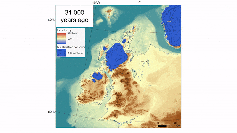
In an animation that spans tens of thousands of years, an ancient ice sheet grows to envelope land masses that would one day be known as Great Britain and Ireland. After thousands of years elapse, the ice then retreats to expose the land once more.
Known as the British-Irish ice sheet, the frozen mass began its relentless march about 33,000 years ago. Around 10,000 years later, the land was covered in ice half a mile thick. But just 5,000 years after that, the glacier had melted away, vanishing in a mere blink of geological time. Human populations that had fled a millennia-long winter returned to settle the thawing land just as the last ice age drew to a close on Earth.
Representing years of research, this animation highlights how quickly the British-Irish Ice Sheet declined. And the data driving the animation may help scientists to better understand how modern ice loss due to climate change contributes to sea-level rise.
Related: 'Death throes' of ancient ice sheets carved hidden valleys below the seafloor
Scottish geologist Archibald Geikie first mapped the British-Irish Ice Sheet's shape in 1894 and, over the past century, scientists have slowly carved out details of its formation and decline, publishing their findings in more than 1,000 scientific publications, according to the website of BRITICE-CHRONO a five-year, $4.2 million endeavor to map the British-Irish Ice Sheet. Ultimately it was the specter of human-caused climate change that drove one team of BRITICE-CHRONO researchers to bring together existing data and collect more; they published their findings Sept. 7 in the journal Boreas. In creating the new animation, the scientists visualized the most complete picture to date of the ancient ice sheet's rise and fall.
The BRITICE-CHRONO team scoured prior studies and compiled data on more than 20,000 landforms that currently exist along the path of the ice sheet — from hill-like drumlins, or small ridges, to masses of soil and rock left behind by the moving glacier. The scientists then visited locations on land and sea, collecting data from 914 sites — some of which were only accessible via submarine, they reported in the study. They calculated the geometric contours of the ice sheet from features in the terrain, estimating the timing of the glacier's retreat from carbon-dated sediment, including animal remains.
Their efforts produced three times more data than any prior simulation of the British-Irish ice sheet; the team then fed the data into a computer model that assessed how the ice would have interacted with its environment over tens of thousands of years. Their animation presented the resulting maps as a time-lapse of the glacier's expansion and eventual demise.
Although this particular ice sheet melted thousands of years ago, the details of its growth and collapse may hold lessons for climate scientists studying the alarming decline of two modern ice sheets: one in Antarctica and the other in Greenland. Since 1901, these two ice sheets have lost 49,000 gigatonnes of ice — enough to coat the United States in 22 feet (6.7 meters) of ice, or enough to cover the entire surface of the moon in an ice sheet five feet (1.5 m) tall, according to NASA.
That melted ice ended up in the ocean, where it has been the single largest contributor to sea-level rise in the past few decades, according to the United Nations' International Panel on Climate Change. Even if humans were to cut all fossil fuel emissions tomorrow, a 2022 study in Nature Climate Change suggests that ice lost from the Greenland ice sheet would still cause a 10-inch (25-centimeter) sea level rise.
Rising sea levels, in turn, will likely mean more punishing storms with worse flooding; the disruption of fragile ecosystems; and the mass displacement of millions of people who live along the coast. Projects such as BRITICE-CHRONO, which look back at the lifespans of long-gone ice sheets, may help scientists predict the decline of modern ice sheets and plan for the future, the researchers reported.
Join our Space Forums to keep talking space on the latest missions, night sky and more! And if you have a news tip, correction or comment, let us know at: community@space.com.