Many Earth-observing satellites are keeping their eyes on Hurricane Irma, a Category 5 storm that will soon bear down on islands in the Caribbean Sea.
Irma is now a Category 5 hurricane, the highest possible ranking on the Saffir-Simpson scale. In a statement, the National Hurricane Center (NHC) called the storm "potentially catastrophic" and warned that "preparations should be rushed to completion in the hurricane warning area." [Hurricane Irma in Photos: Monster Storm Seen from Space]
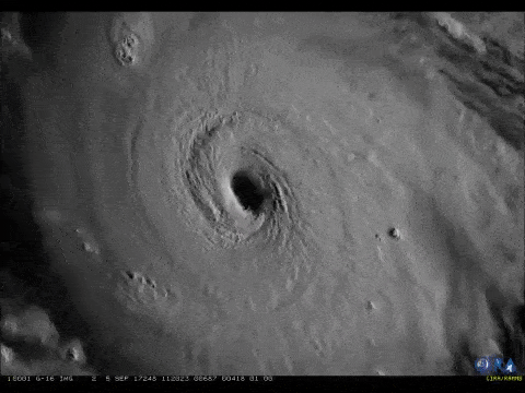
The incredibly turbulent cloud system around the eye of the hurricane was captured in a short video taken earlier today (Sept. 5) by the GOES-16 Earth-observing satellite ("GOES" stands for "Geostationary Operational Environmental Satellite"). As of 8 a.m. EDT (1200 GMT), the storm was about 270 miles (440 kilometers) east of Antigua and about 280 miles (445 km) east-southeast of Barbuda, according to a statement from NASA.
The storm is currently moving toward the Leeward Islands in the Caribbean at about 14 mph (22 km/h), with sustained winds now exceeding 175 mph (280 km/h), according to the statement. Irma is expected to remain a Category 4 or 5 hurricane for at least two to three days, NASA officials said.
The GOES-East satellite — also part of the National Oceanic and Atmospheric Administration's (NOAA) GOES family of satellites — captured the storm's motion between Sept. 2 and Sept. 5 as it moved from the mid-Atlantic toward the Caribbean Sea. The observations were stitched together into the time-lapse video above.

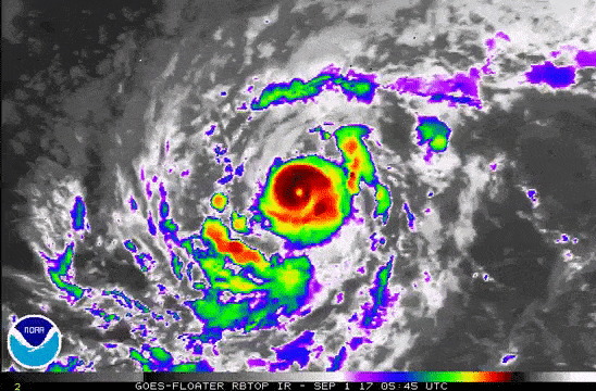
The NASA-NOAA Suomi NPP (National Polar-orbiting Partnership) satellite captured a high-resolution, visible-light image of Hurricane Irma on Sept. 4, before it was upgraded to a Category 5 storm. The Visible Infrared Imaging Radiometer Suite (VIIRS) instrument on the satellite also captured images showing cloud-top temperatures above the storm; these images reveal the rising cloud temperatures near the eye of the hurricane.
External cameras on the International Space Station also captured views of the storm on Sept. 5. The storm's eye is clearly discernable from space, and the surrounding cloud mass dominates almost all of the camera's view.
A hurricane warning is currently in effect for at least 16 Caribbean islands — including Puerto Rico, the Leeward Islands and the U.S. Virgin Islands — and a hurricane watch is in effect for most of the other islands in that area. A hurricane warning is issued for areas where sustained winds of 74 mph (119 km/h) or higher are expected; a watch is issued for areas where those conditions are possible. The NHC now predicts that the storm will likely turn north and hit southern Florida.

Representatives from the Arecibo Observatory in Puerto Rico said in a tweet that they are taking precautions to protect the facility from the impending storm.
The arrival of Irma comes less than two weeks after Hurricane Harvey (which peaked as a Category 4 storm) brought devastating floods to southeast Texas.
Editor's Note: Space.com senior producer Steve Spaleta contributed to this report.
Follow Calla Cofield @callacofield. Follow us @Spacedotcom, Facebook and Google+. Original article on Space.com .
Join our Space Forums to keep talking space on the latest missions, night sky and more! And if you have a news tip, correction or comment, let us know at: community@space.com.