Harvey Storms into Louisiana, and NASA Snaps Images from Space

NASA satellites continue to track the path of Tropical Storm Harvey, which made landfall in Louisiana this morning (Aug. 30).
The sun is finally shining in Houston and parts of southeast Texas that are grappling with the effects of record-setting rainfall and subsequent flooding caused by Harvey. The storm is expected to be downgraded to a tropical depression by this evening, NASA said, but could still dump up to 10 inches (25 centimeters) of rain in some isolated areas of Louisiana.
The National Oceanic and Atmospheric Administration (NOAA) GOES-East satellite captured a high-resolution image of Harvey's massive, swirling white form as it crept over Louisiana at 7:30 a.m. CDT (8:30 a.m. EDT/1230 GMT). The center of the storm made landfall at 4 a.m. CDT (5 a.m. EDT/0900 GMT), according to the agency. [Hurricane Harvey: Photos of the Massive Storm from Space]

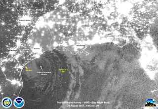
A nighttime image of the storm was captured by the Visible Infrared Imaging Radiometer Suite (VIIRS) instrument aboard the joint NASA-NOAA Suomi NPP satellite at 3:03 a.m. CT (4:03 a.m. EDT/0803 GMT) today. The image shows the center of storm's circulation hovering over the Gulf of Mexico, about 1 hour before it made landfall.
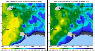
NASA's Soil Moisture Active Passive (SMAP) satellite, which measures soil moisture on Earth's surface, captured a view of southeastern Texas on Aug. 21 and 22, showing that the surface soil was already fairly wet, even before Harvey made landfall. Another image captured on Aug. 25 and 26, following Harvey's landfall there, showed moisture levels greatly higher along the coast.
Astronauts on the International Space Station have continued to tweet pictures of the storm from space and send their well wishes to people on the ground. Randy Bresnik, a NASA astronaut living on the station, tweeted a photo of sunrise and wrote, "Houston is reporting blue sky for the first time in many days! May this sunrise start the healing process."
Jack Fischer, another NASA astronaut on the station, tweeted a picture of the storm and wrote, "Harvey fills the window creating a path of destruction as it traverses the Gulf. Praying for the people there and hoping for sunshine."
Get the Space.com Newsletter
Breaking space news, the latest updates on rocket launches, skywatching events and more!
The space station is managed from the Mission Control center at NASA's Johnson Space Center (JSC) in Houston. The facility is closed through Labor Day to all but mission-critical staff due to the flooding. On the JSC emergency management Twitter account, officials wrote, "Assessment and recovery teams underway. Beautiful day today."

Harvey is expected to continue to move inland, reaching as far north as Tennessee before its intensity significantly decreases, according to the National Weather Service.
Overnight (Aug. 29 to 30), Harvey struck hard at the Beaumont/Port Arthur area of southwest Texas, dropping an additional 12.5 inches (32 cm) of rain in some areas, NASA said. On average, southwest Louisiana and nearby areas are expected to receive 3 to 6 inches (8 cm to 15 cm) of rainfall as Harvey moves north, but isolated areas could receive as much as 10 inches (25 cm), according to the agency.
Follow Calla Cofield @callacofield. Follow us @Spacedotcom, Facebook and Google+. Original article on Space.com.
Join our Space Forums to keep talking space on the latest missions, night sky and more! And if you have a news tip, correction or comment, let us know at: community@space.com.

Calla Cofield joined Space.com's crew in October 2014. She enjoys writing about black holes, exploding stars, ripples in space-time, science in comic books, and all the mysteries of the cosmos. Prior to joining Space.com Calla worked as a freelance writer, with her work appearing in APS News, Symmetry magazine, Scientific American, Nature News, Physics World, and others. From 2010 to 2014 she was a producer for The Physics Central Podcast. Previously, Calla worked at the American Museum of Natural History in New York City (hands down the best office building ever) and SLAC National Accelerator Laboratory in California. Calla studied physics at the University of Massachusetts, Amherst and is originally from Sandy, Utah. In 2018, Calla left Space.com to join NASA's Jet Propulsion Laboratory media team where she oversees astronomy, physics, exoplanets and the Cold Atom Lab mission. She has been underground at three of the largest particle accelerators in the world and would really like to know what the heck dark matter is. Contact Calla via: E-Mail – Twitter
