Stunning Detail Revealed in Solar System Geology Maps
Pluto
From moving lights in the night sky, we now understand that planets, moons and dwarf planets are actual places. Some of them have weather, auroras and other features that are similar to Earth. One key to help us better understand a world's history is by charting its terrain. By figuring out what kinds of ground there are and how high they are, we can begin to trace events such as impacts and mountain-building. Here are a few cool geology maps from around the solar system.
PHOTOS: Dive Onto Pluto's High-Resolution Landscape
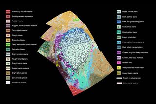
We didn't know much about Pluto at all until the New Horizons spacecraft flew past the dwarf planet last year. Today, high-resolution pictures are still flowing back to us from deep space. This recent example shows a nitrogen-ice plain that is informally called Sputnik Planum. You can see many different types of terrain, ranging from mountains to hills to nitrogen-ice plains. NASA wrote that this research helps scientists identify which of these features formed first. "For example," the agency said, "the yellow craters (at left, on the western edge of the map) must have formed after their surrounding terrain."
Titan
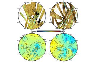
Titan is the largest moon of Saturn and is an interesting place to examine in Saturn's system. It has an atmosphere, hydrocarbon lakes and a liquid cycle similar to what we see here on Earth. These 2013 images from the Cassini spacecraft represent the first global topographic map of the moon, and were identified by NASA as a way to help pinpoint some of the finder details of the liquid cycle.
10 Years Later: When Huygens Landed on Titan
"It's especially helpful to those studying hydrology and modeling Titan's climate and weather, who need to know whether there is high ground or low ground driving their models," said map-design leader Ralph Lorenz, a member of the Cassini radar team based at the Johns Hopkins University Applied Physics Laboratory in Maryland, in a statement.
Mars
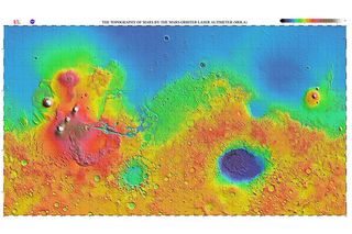
We have lots of pictures of Mars over the centuries, but topographic data is a little more sparse. This is an example of a map created by the now-retired Mars Global Survey Mission, using its Mars Orbiter Laser Altimeter. You can see great contrasts between the north and south of Mars in this global image. The northern hemisphere is generally at a lower elevation than the southern one, for example. Most of the mountainous terrain is also concentrated in one area, at left. Scientists are still puzzling out how Mars' history could have produced this, but it's possible that water was a factor in it.
Get the Space.com Newsletter
Breaking space news, the latest updates on rocket launches, skywatching events and more!
PHOTOS: The Psychedelic Landscape of Mars
Venus
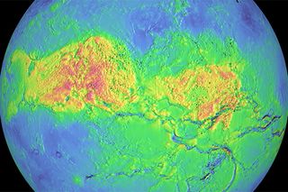
Venus has an impossible-to-see surface using your eyes because it is shrouded in thick cloud. Radar, however, can penetrate down to the surface and show us the hellish, lava-filled terrain below.
PHOTOS: Japanese Spacecraft Has New Eyes on Venus
This is a 1990s-era map taken by the NASA spacecraft Magellan showing Aphrodite Terra, the largest highland on Venus. It is believed that there could be volcanic eruptions on Venus even today, which would potentially change the terrain fairly quickly. We'll need more long-term missions to learn more; the long-running Venus Express concluded last year and the Japanese mission Akatsuki has just arrived.
Mercury
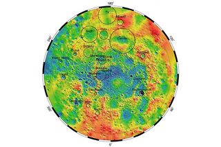
Mercury was never mapped in detail until the arrival of the MESSENGER (MErcury Surface, Space ENvironment, GEochemistry, and Ranging) mission, which concluded last year. Here you can see an example of what the Mercury Laser Altimeter was capable of. This map particularly highlights craters, which are a common feature on Mercury because the planet does not have a substantial atmosphere.
Join our Space Forums to keep talking space on the latest missions, night sky and more! And if you have a news tip, correction or comment, let us know at: community@space.com.

Elizabeth Howell (she/her), Ph.D., is a staff writer in the spaceflight channel since 2022 covering diversity, education and gaming as well. She was contributing writer for Space.com for 10 years before joining full-time. Elizabeth's reporting includes multiple exclusives with the White House and Office of the Vice-President of the United States, an exclusive conversation with aspiring space tourist (and NSYNC bassist) Lance Bass, speaking several times with the International Space Station, witnessing five human spaceflight launches on two continents, flying parabolic, working inside a spacesuit, and participating in a simulated Mars mission. Her latest book, "Why Am I Taller?", is co-written with astronaut Dave Williams. Elizabeth holds a Ph.D. and M.Sc. in Space Studies from the University of North Dakota, a Bachelor of Journalism from Canada's Carleton University and a Bachelor of History from Canada's Athabasca University. Elizabeth is also a post-secondary instructor in communications and science at several institutions since 2015; her experience includes developing and teaching an astronomy course at Canada's Algonquin College (with Indigenous content as well) to more than 1,000 students since 2020. Elizabeth first got interested in space after watching the movie Apollo 13 in 1996, and still wants to be an astronaut someday. Mastodon: https://qoto.org/@howellspace
