Satellite Photo Shows Hurricane Irene Battering US East Coast

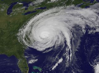
A new view of Hurricane Irene from a satellite orbiting Earth shows the powerful storm just after it made landfall on the U.S. East Coast today (Aug. 27).
The new hurricane photo, taken by NOAA's GOES 13 weather satellite 22,300 miles (nearly 36,000 km) above Earth, shows Irene as it appeared at 10:10 a.m. EDT (1410 GMT).
"At that time Irene's outer bands had already extended into New England," Rob Gutro of NASA's Goddard Space Flight Center in Greenbelt, Md., wrote in a hurricane update. [Hurricane Irene Photos From Space]
Irene made landfall in Cape Lookout, N.C., today at about 8 a.m. EDT (1200 GMT) as a Category 1 storm, with maximum sustained winds of about 85 mph (136 kph). The storm has been lashing the U.S. Eastern Seaboard and at least two deaths directly caused by the hurricane have been reported, according to news reports.
"The storm surge and rough waves it brought have been severely battering the coast," Gutro explained.
By 11 a.m. EDT (1500 GMT), the Weather Channeled reported that Irene's sustained winds at Nags Head, N.C., were about 65 mph (104 kph). Two tornadoes were reported in Virginia Beach, Va., and a tornado watch was in effect, NASA officials said. [Infographic: How, When & Where Hurricanes Form]
"At that time, the first rainfall from Irene's outer bands reached the Washington, D.C. area bringing brief moderate to heavy rainfall," Gutro wrote. When the first rains fell on Washington, the center of Irene was about 50 miles (80 km) west of Cape Hatteras, N.C. — about 328 miles (527 km) southeast of Washington, he added.
Get the Space.com Newsletter
Breaking space news, the latest updates on rocket launches, skywatching events and more!
NASA satellites have watched Hurricane Irene swell in size over the last week, with the storm's diameter growing from 200 miles (321 km) across to a whopping 600 miles (965 km). By mid-day today, Irene's influence had dipped to about 520 miles (836 km), with tropical-storm-force winds prevalent along its outer rim while hurricane strength winds extend up to 180 miles (289 km) from the hurricane's center.
Current forecasts predict that Irene will bring up to 10 inches of accumulated rainfall, with some isolated regions seeing up to 15 inches, between eastern North Carolina to the mid-Atlantic states, eastern New York and the New England interior.
"Irene is now forecast by the National Hurricane Center to take a more inland track and maintain hurricane force near coastal New York, western Connecticut and western and central Massachusetts," Gutro wrote.
Several NASA space and research centers in Virginia, Washington and New York City are on alert for Hurricane Irene. A storm surge of about 2 feet is expected at the space agency's rocket launch facility on Wallops Island, Va.

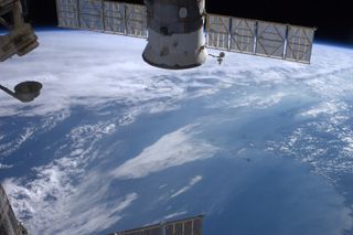
Astronauts in space have also been tracking the progress of Hurricane Irene. The six-man crew of the International Space Station has been snapping photos of Irene daily, with NASA astronaut Ron Garan posting photos on Twitter, where he writes as @Astro_Ron.
Today, Garan posted a photo of the northeastern coast near New York City, Boston and Cape Cod ahead of Irene's arrival. [Astronaut Ron Garan's Amazing Space Photos]
"#NYC#Boston + #Cape #Fromspace in 'Calm before the Storm' as #Irene visibly looms offshore," Garan wrote in his post. "Plz be prepared."
You can follow SPACE.com Managing Editor Tariq Malik on Twitter @tariqjmalik. Follow SPACE.com for the latest in space science and exploration news on Twitter @Spacedotcom and on Facebook.
Join our Space Forums to keep talking space on the latest missions, night sky and more! And if you have a news tip, correction or comment, let us know at: community@space.com.

Tariq is the Editor-in-Chief of Space.com and joined the team in 2001, first as an intern and staff writer, and later as an editor. He covers human spaceflight, exploration and space science, as well as skywatching and entertainment. He became Space.com's Managing Editor in 2009 and Editor-in-Chief in 2019. Before joining Space.com, Tariq was a staff reporter for The Los Angeles Times covering education and city beats in La Habra, Fullerton and Huntington Beach. In October 2022, Tariq received the Harry Kolcum Award for excellence in space reporting from the National Space Club Florida Committee. He is also an Eagle Scout (yes, he has the Space Exploration merit badge) and went to Space Camp four times as a kid and a fifth time as an adult. He has journalism degrees from the University of Southern California and New York University. You can find Tariq at Space.com and as the co-host to the This Week In Space podcast with space historian Rod Pyle on the TWiT network. To see his latest project, you can follow Tariq on Twitter @tariqjmalik.
